AccuWeather


- Special Weather Statement
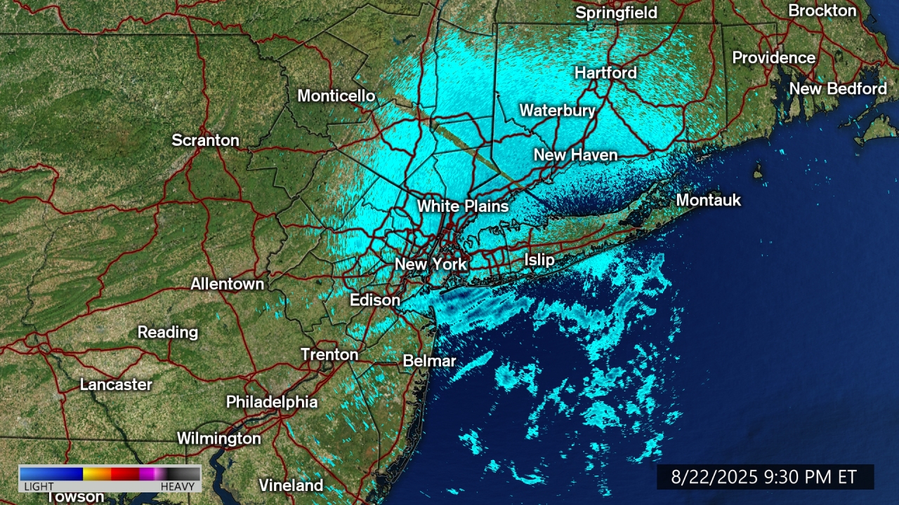
At 752 AM EDT, Doppler radar was tracking strong thunderstorms capable of producing small hail along a line from Englewood to the Lower East Side to Oakwood. Movement was east at 50 mph. HAZARD...Pea size hail. SOURCE...Radar indicated. IMPACT...Minor hail damage to outdoor objects is possible. Locations impacted include... Jamaica, Yonkers, Flatbush, New Rochelle, Flushing, Mott Haven, Hoboken, East Tremont, Freeport, Valley Stream, Long Beach, Port Chester, Glen Cove, Coney Island, and Garden City.More
- Special Weather Statement
At 736 AM EDT, Doppler radar was tracking a strong thunderstorm over Fahnestock State Park, or near Cold Spring, moving east at 40 mph. HAZARD...Half inch hail. SOURCE...Radar indicated. IMPACT...Minor hail damage to outdoor objects is possible. This strong thunderstorm will be near... Fahnestock State Park around 740 AM EDT. Lake Carmel around 745 AM EDT. Carmel around 750 AM EDT.More
- Coastal Flood Statement
* WHAT...Up to one half foot of inundation above ground level expected in vulnerable areas near the waterfront and shoreline. * WHERE...In New Jersey, Hudson County. In New York, Southern Queens County. * WHEN...This evening. * IMPACTS...Brief minor flooding of the more vulnerable locations near the waterfront and shoreline. * ADDITIONAL DETAILS...Additional minor coastal flooding is expected for Thursday and Friday night's high tide cycles.More
- Coastal Flood Advisory
* WHAT...Up to one foot of inundation above ground level expected in vulnerable areas near the waterfront and shoreline. * WHERE...Southern Nassau County. * WHEN...From 8 PM to 11 PM EDT this evening. * IMPACTS...Minor flooding in the more vulnerable locations near the waterfront and shoreline. Some roads and low lying properties including parking lots, parks, lawns, and homes and businesses with basements near the waterfront will experience minor flooding. * ADDITIONAL DETAILS...Additional coastal flooding is expected for Thursday and Friday night's high tide cycles.More
- Coastal Flood Advisory
* WHAT...Up to one foot of inundation above ground level expected in vulnerable areas near the waterfront and shoreline. * WHERE...In Connecticut, Southern Fairfield County. In New York, Southern Westchester County. * WHEN...From 11 PM this evening to 2 AM EDT Thursday. * IMPACTS...Minor flooding in the more vulnerable locations near the waterfront and shoreline. Some roads and low lying properties including parking lots, parks, lawns, and homes and businesses with basements near the waterfront will experience minor flooding. * ADDITIONAL DETAILS...Additional coastal flooding is expected for Thursday and Friday night's high tide cyclesMore
- Special Weather Statement
At 752 AM EDT, Doppler radar was tracking strong thunderstorms capable of producing small hail along a line from Englewood to the Lower East Side to Oakwood. Movement was east at 50 mph. HAZARD...Pea size hail. SOURCE...Radar indicated. IMPACT...Minor hail damage to outdoor objects is possible. Locations impacted include... Jamaica, Yonkers, Flatbush, New Rochelle, Flushing, Mott Haven, Hoboken, East Tremont, Freeport, Valley Stream, Long Beach, Port Chester, Glen Cove, Coney Island, and Garden City.More
- Coastal Flood Advisory
* WHAT...Up to one half foot of inundation above ground level expected in low-lying areas near shorelines and tidal waterways. * WHERE...Middlesex, Western Monmouth and Eastern Monmouth. * WHEN...From 8 PM this evening to 2 AM EDT Thursday. * IMPACTS...At this level, flooding begins on the most vulnerable roads in coastal and bayside communities, and along inland tidal waterways. Some partial or full road closures are possible. * ADDITIONAL DETAILS...Another round of minor coastal flooding is forecast Thursday night.More
- Coastal Flood Statement
* WHAT...Up to one half foot of inundation above ground level expected in vulnerable areas near the waterfront and shoreline. * WHERE...In New Jersey, Hudson County. In New York, Southern Queens County. * WHEN...This evening. * IMPACTS...Brief minor flooding of the more vulnerable locations near the waterfront and shoreline. * ADDITIONAL DETAILS...Additional minor coastal flooding is expected for Thursday and Friday night's high tide cycles.More
- Special Weather Statement
At 736 AM EDT, Doppler radar was tracking a strong thunderstorm over Fahnestock State Park, or near Cold Spring, moving east at 40 mph. HAZARD...Half inch hail. SOURCE...Radar indicated. IMPACT...Minor hail damage to outdoor objects is possible. This strong thunderstorm will be near... Fahnestock State Park around 740 AM EDT. Lake Carmel around 745 AM EDT. Carmel around 750 AM EDT.More
- Coastal Flood Advisory
* WHAT...Up to one foot of inundation above ground level expected in vulnerable areas near the waterfront and shoreline. * WHERE...In Connecticut, Southern Fairfield County. In New York, Southern Westchester County. * WHEN...From 11 PM this evening to 2 AM EDT Thursday. * IMPACTS...Minor flooding in the more vulnerable locations near the waterfront and shoreline. Some roads and low lying properties including parking lots, parks, lawns, and homes and businesses with basements near the waterfront will experience minor flooding. * ADDITIONAL DETAILS...Additional coastal flooding is expected for Thursday and Friday night's high tide cyclesMore


